
- cross-posted to:
- space@mander.xyz
- cross-posted to:
- space@mander.xyz
cross-posted from: https://lemmy.world/post/45115923
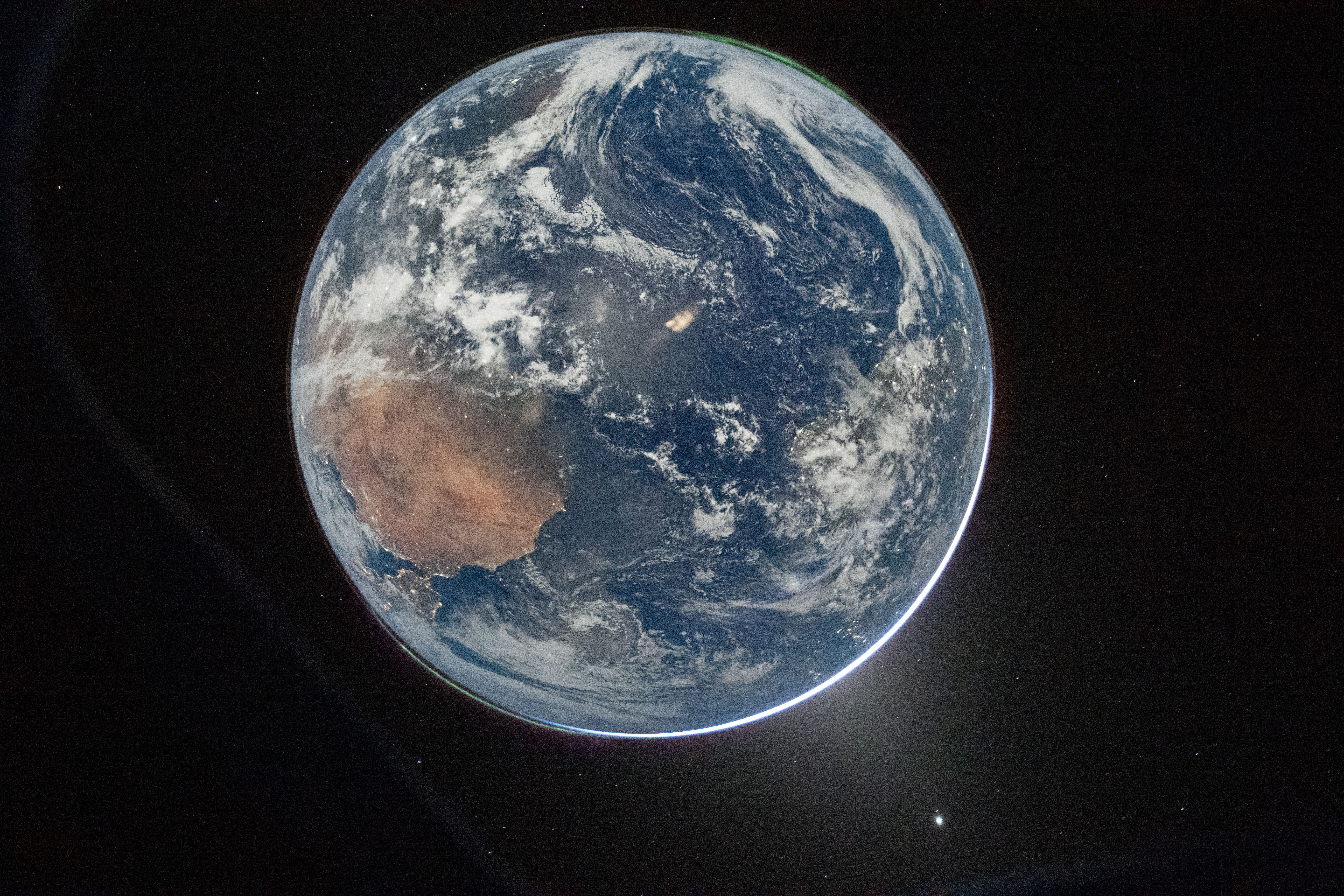
This image of home just came down from the Artemis II crew.
Taken after their translunar injection burn, there are aurorae at top right and lower left, and zodiacal light at lower right.
Credit: NASA/Reid Wiseman
// That’s home. That’s us.
-–
Alternative references with a better quality mentioned in comments by @baguette@piefed.social:
- https://images.nasa.gov/details/art002e000192;
- https://images-assets.nasa.gov/image/art002e000192/art002e000192~orig.jpg [5568 x 3712]
You must log in or # to comment.
Is that upside down? Looks like the strait of Gibraltar bottom left but with Africa on top, and the mid Atlantic centre of the globe
Define upside down.
Also… “That’s here. That’s home. That’s us. On it everyone you love, everyone you know, everyone you ever heard of, every human being who ever was, lived out their lives.”
“Upside-down” in relation to the north–south orientation of the poles. Which of course is human-defined, but it seems easy enough to understand what they mean.
Which of course is human-defined
Is it? The ellipticals around the sun are more or less level, so there’s definitely a vertical axis, which the Earth’s poles don’t perfectly line up with, but they don’t flip flop across that plane either.
The sun’s orbit around the Milky Way has more of a sinusoidal path, but it’s still pretty consistently on a level plane more or less.
The only question is “which way is up, and which way is down?” Although we don’t know quite enough about the universe yet to say for certain (unless we wanted to somehow base it off of the flow direction of magnetic fields), for all we know there could be a density gradient in dark matter, to where the planes of the solar system’s ellipticals or the Milky Way’s orbit are effectively sitting at the level where the “empty space” below it is denser, and the “empty space” above it is less dense.
That’s just speculation of course, and I’m by no means asserting that it is that way. Just raising a hypothetical. If true it might help to explain why mass bends the topology of spacetime.
Of course it could also potentially be very easily disproven by identifying a black hole with a high density that’s located somewhere “above” the plane of the Milky Way; barring any unforseen mitigating factors like a giant floaty beyond the event horizon that we can’t observe but which raises the total buoyancy of the black hole…
The only question is “which way is up, and which way is down?”
Yeah, that’s the human-defined part I was referring to. I could’ve spoken more clearly. The Earth’s electromagnetic field is obviously a real thing with a real, measurable orientation; it’s why compasses work. I wasn’t saying “the line along which the compass needle lies is human-defined”*, but rather that the end of the needle we choose to paint red and collectively define as “up” on Earth’s 2-sphere surface is human-defined. There are real, understandable societal and historical factors that play into why the North Pole is “up”, but this photo is only upside-down from the collective notion that the South Pole is “down” rather than “up”.
“From the perspective of the widely accepted social construct” is thus the only thing they would’ve realistically meant.
* I know the terrestrial and magnetic poles diverge somewhat. Close enough for a discussion of “upside-downness”.
I get it, that’s why my blurb about magnetic poles was in parentheses. I said “somehow” because I recognize that “North is up” is a social construct.
It’s also arbitrary whether the movement of ions away from the earth at the north pole, and towards the earth at the south pole, has any indication on “up or down.” So that doesn’t really help either.
My main point was speculation about the universe having a density gradient, where dark matter would be denser below the plane of the galaxy than it is above. That would provide an objective frame of reference. But of course it’s completely speculative and probably easily disproven. I just don’t know if it’s ever even been considered…
Old Carl had a way with words, huh?
.dn ʎɐʍ ʇɥƃᴉɹ ǝɥʇ sʇᴉ ,oN
?huoht tfel ot thgir ti si yhW
Because it’s rotated, not mirrored.
?em ot yas uoy kcuf ehT
A̵̭̎̏̅̓́l̴̡̨̘̦͍̗̩̻͈͓̱̺͕̉̋̋̑͟i̵̫̭̭̒̅̆̿̾̃̇̋͋́̈́̚͟͝͠ḙ̷͎̘͍̞͎̥̺͛̄͟͟ͅn̴̡̲̺̯̜̗̯͂̅̓̌̌͘͘̚͡͡͡s̷̡̲͕͉̈́͗̑̆̂͛̃̾̊̈́̉͊̕͟
It’s hard to make out. My first thought was Australia, maybe?
(Edit: wait, I think you’re right)
Yeah, Gibraltar is at the 7-8 o’clock position and Africa is on the top half.
East is up and the equator is vertical in this shot
Top right the green is aurora australis, and if you look closely you can see the coast of Brazil on the right. The equator would be like a smile across the globe from left to right.
Yeah, the equator is at almost a 45 degree angle. My bad. But that’s definitely Gibraltar at 8 o’clock
That’s home. That’s us.
Sorry guys, I blinked. Can we take it again?
Why is there so much ISO noise?
It’s a pic of the night side shot at ISO 51200.
Far be it for me to second-guess an astronaut, but I’m not sure it was necessary to turn the gain up so high as to make it look like daylight.
deleted by creator
Aw, man, the dark version is still noisy too. : (
I guess it would’ve had to be nearly black except for the city lights in order to not be like that.
Exactly what I’d expect a grue to say…
deleted by creator
Far right, there’s South America


